ROMAN NORTH WALES: DAY 2
Forts, Scenery and Unexpected Hikes.

So we’ve already discovered three incredible Roman Sites off the main Roman road of Watling Street, following in the footsteps of the Roman Legionnaires. But now it’s time to get off the beaten track and enter some of the more remote areas to uncover incredible ancient landscapes and long lost Roman sites and outposts.
As Roman North Wales was a landscape dominated by the military it would have been full of forts and small outposts. These small and remote posts would have been key parts to the strategy and the structure that the Romans created to protect their vital trade routes and fight off the resistant Celtic Tribes. Often these outposts would be abandoned after a brief period of occupation and simply left, forgotten, to be consumed back into the natural landscape.
So we are going to track them down and rediscover these incredible locations to see for ourselves just why these sites were chosen and how important they were to the main Roman occupation of North Wales. Do they all connect somehow and how would they have supported each other?
Often these outposts would be abandoned after a brief period of occupation and simply left, forgotten, to be consumed back into the natural landscape.

Holyhead Mountain
Just two miles from the Holyhead Harbour Town in Anglesey is the South Stack Cliffs RSPB Nature Reserve, and upon this stretch of heathland and farmland across the sea cliffs it’s not just rare puffins and guillemots to be found, there is a wealth of ancient activity in the area that goes back for thousands and thousands of years.
Compared to much of North Wales, which is rather mountainous, Anglesey is relatively low and flat providing excellent fertile plains for agriculture and farming as well as having an ancient and important trade link with Ireland where goods have been traded even as far back as the Neolithic Era. Anglesey also possesses a humongous copper mine that at the time would have been the largest copper mine in the world providing an incredibly rich source of resources. So it's no wonder really why the Romans were desperate to get their hands onto this invaluable little isle off the coast of North Wales.
There was just one problem. Anglesey was possibly the place in North Wales that was the most fiercely resistant to the Roman Occupation as it was an important and sacred stronghold for the Druidic and Celtic Tribes already existing here. For the Druids especially, Anglesey was an incredibly sacred site and religious location where they brought up the next Druidic Priests. The Druids had a strong connection to nature and being enveloped by the outstanding natural beauty that is present upon the South Stack Cliffs it isn’t hard to see why Anglesey was so important and sacred to them. But to the Romans this only fortified their need to take Anglesey as the Druid Religion was so alien to their own beliefs that they simply wanted every trace of it gone.
Hiking (yes it wasn’t quite the 10 min adventure we initially thought it was going to be) over the craggy headland of the South Stack Cliffs nature reserve and being battered by the strong headwind it’s hard to imagine why a civilisation would want to exist on this incredible landscape where bracken and heather seem to be the highest link in the food chain. That is until you take in the incredible view and it all falls into place exactly what brought these ancient civilisations up this rugged mountain.
The highest peak of Holyhead Mountain is the first sight of land for travellers or invaders coming across the strait from Ireland and the summit itself affords an incredible view across not only the watery horizon, but much of the flat and fertile plains of Anglesey. It’s an incredible location for a lookout and defence. So that's what brings all of these ancient civilisations up this mountain, defence. The neolithics, the celtic, the druidic and of course the Roman.
That is until you take in the incredible view and it all falls into place exactly what brought these ancient civilisations up this rugged mountain.

Wandering across this landscape we were both overtaken by quite a strong feeling, the land feels almost untouched by man and there's this connection to nature and the land that heightens all of your senses as you navigate this rather remote and sometimes tricky rocky landscape.
Much of the nature reserve itself is taken up by an incredible iron age hill fort that surrounds almost 7 hectares of land; it's hard to set foot upon this landscape without entering into the land of the Celts. But what is really hard is to imagine what such a location would have felt like to the Romans entering it for the first time. It's the furthest and remotest part of Anglesey right at the tip of North Wales and completely different to any other kind of landscape they would be familiar with from Roman Britain, it’s also heavily occupied by a tribe that really doesn’t want you around. Two words come to mind: desolate and hostile.
But despite all of this they had an outpost here, a 2nd - 4th Century Watch and Signal Tower that was located at the summit of the Holyhead Mountain offering the best vantage point and signalling point for the Roman Defences. The main and sole job of this watchtower was to watch the horizon and warn of threats like Irish Raiders after the important resources the Romans were busy exploiting out of the region. If a threat was seen then a huge beacon would be lit to warn both the small harbour fort of Caer Gybi in the Holyhead Harbour as well as the much larger Roman Fort: Segontium that could mobilise the necessary reinforcements and troops to squash the threat.
We emerged from the nature reserve after two and a half insane hours of soaking in this ancient landscape and pulled up right round the corner at our air bnb that was situated practically on the slope of the Holyhead Mountain. Perfect location really. A night on what could be the same spot as a legionnaires camp after a successful conquest of Anglesey. The following morning sees us leaving the isle of Anglesey on a quest to follow the signal from the Holyhead Mountain Watchtower to its receiver, the Roman Fort of Segontium.
It's the furthest and remotest part of Anglesey right at the tip of North Wales and completely different to any other kind of landscape they would be familiar with from Roman Britain, it’s also heavily occupied by a tribe that really doesn’t want you around.
Segontium
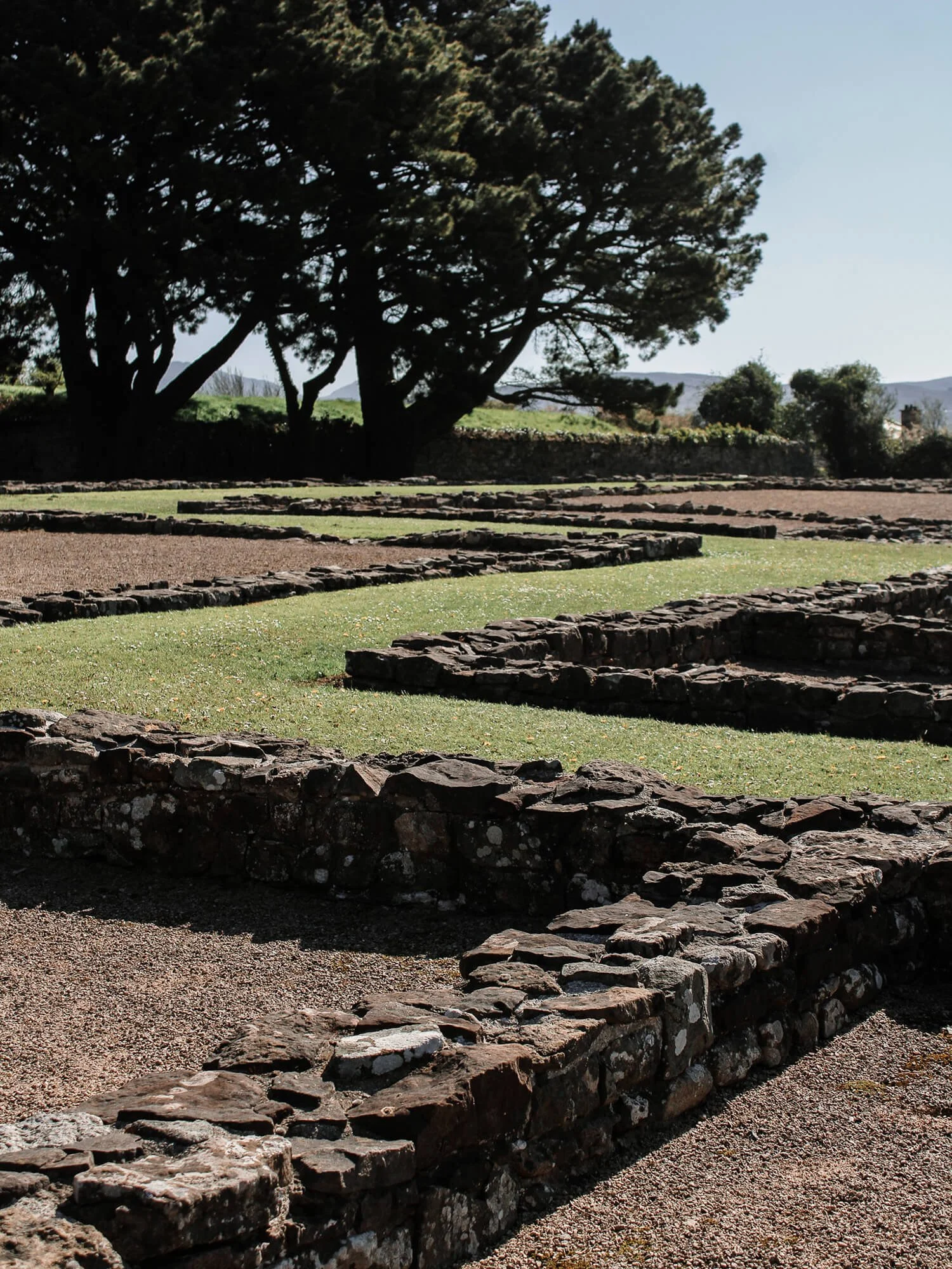
Segontium can be found on the streets of the royal town of Caernarfon and it’s actually the largest and most important Roman Fort in the whole of the North Wales Occupation. Rather unexpectedly, and much like the bathhouse at Prestatyn from our first leg of the Roman North Wales Adventure, Segontium is situated in the middle of a large residential area, its foundations left excavated and exposed as a public park.
Segontium was founded in 77AD and rather uniquely it was occupied right up until the end of Roman Rule in Britain, no other fort in Wales was held for so long. But why was it? Well at the time of the Roman Occupation of North Wales the site of Segontium was at a key position in the military network that was being established across the region. It was the main hub, the administrative centre if you like for all of the military activities in the area. Its easy to see why as located at almost the mouth of the connection to Anglesey Segontium was n the perfect position to protect this heavily rich in minerals area with a clear view of the Holyhead Summit and the watchtower outpost present upon its peak.
The first excavations at Segontium were undertaken in the 1920’s by the archaeologist R.E.M Wheeler and much of the stone buildings that you can see at the site today were uncovered during these excavations. The site itself is possibly one of the vastest expanses of excavated foundations that we have ever witnessed with the whole blueprint and structure of the Roman Fort visible.
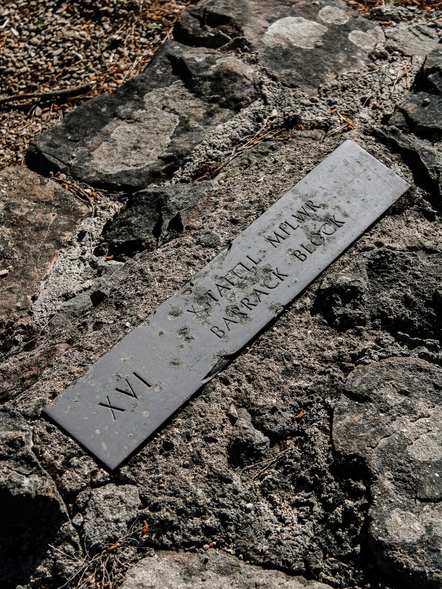
The fort itself was a heavily fortified structure with four entrance gates and an encircling defensive wall that enclosed the barracks and buildings within its centre. Rather excitingly and unusually there's even the foundations to a large courtyard house that would have been used for the visit of important Roman Military Officials, an impressive foundation that even contains its own personal bathhouse.

It was the main hub, the administrative centre if you like for all of the military activities in the area.
Around the fortified fort would have been a large settlement containing a public bathhouse as well as a Roman Temple for worship and the whole site would have been supplied by its own personal aqueduct. It is actually repairs to this Aqueduct in 200 AD that rather rarely provide us with the identity of one of the Roman Legions to be stationed here at Segontium as the work was recorded in an inscription. This was the First Cohort of Sunici, a Roman Legion that had been sent to this Welsh Roman Hub all the way from Germany.
The fact that we are even able to walk around such an impressive structure and blueprint of stone almost wasn’t possible as much later in its history and after the Romans were long gone it came under threat to some military builders hunting for masonry to recycle … It was the time of Edward I and he was in the middle of building his castle at Caernarfon, he needed lots of stone for his castle so simply plundered the crumbling Roman Ruins of the largest Roman Fort in the area, Segontium.
So we’ve just visited the command centre, the pinnacle of the Roman Military Network of North Wales and seen how these sites all worked together to control and protect the important mineral region of Anglesey. But what about all of these precious minerals that were being exploited out of the region? How would they have been protected as they travelled across some of the more remote and dramatic Welsh landscapes? Well pulling up into a layby in the Snowdonia Region we were ready to explore what life would have been like for the network of remote military outposts and camps that served to protect these important trade routes.
Yet again we discovered that, much like the ancient landscape at the South Stack Cliffs Nature Reserve, accessing the Roman Site of Tomen y Mur hidden in the Snowdonia hills and mountains would unfortunately involve another hike. But just a short 20 - 30 min one this time. A lack of parking availability means that this location is best accessed by foot, we ended up having the full experience and entered the site as the legionnaires would, tired and slightly out of breath from climbing the hill.

The fact that we are even able to walk around such an impressive structure and blueprint of stone almost wasn’t possible as much later in its history and after the Romans were long gone it came under threat to some military builders hunting for masonry to recycle …

Tomen y Mur
Tomen y Mur is a rather special first century fort in Snowdonia. Despite its rather remote location it is actually situated at the crossing of four Roman Roads and was placed there as part of a series of fort outposts that protected these important highways from the uprisings of a particularly troublesome local Celtic Tribe, the Ordovices Tribe.
But what makes this fort so special and unusual to visit is actually down to this remote location. In order to keep the troops entertained, and almost as a form of compensation for the isolated posting, a small military amphitheatre was installed for the hosting of various sports and games. The presence of a small military amphitheatre upon this site is one that is incredibly rare within Roman Britain, amphitheatres in themselves are a rare find with only twelve known examples in the country, but for there to be an example of a much smaller and more bespoke created amphitheatre is a real gem of history hidden within these snowdonia hills.
This fort site, most likely down to its remote location, wasn’t occupied for much longer than 70 years before being abandoned and left to be reclaimed by the landscape after a military presence was no longer needed to protect the vital trade routes across Snowdonia. However it would have been quite the establishment with this rare military amphitheatre, a parade ground, a bathhouse, a grand house for visiting officials, burial mounds and even a temple site. Standing within the boundaries of the fort itself it is easy to see why this location was chosen for such an outpost, not only is at the junction of four roman roads, but being situated on this large expanse within the Snowdonia Valleys allows for an incredible vantage point for miles, able to spot any advancing forces with ease.
A large portion of the stone Fort Wall has been reconstructed by the Snowdonia National Park Authority in 2007 using original Roman Stone that was disturbed in the 1940’s when rather bizarrely a stray WW2 Bomb struck a cow house built into the side of the Roman Fort and scattered the debris. This reconstruction shows what the wall would have originally looked like and gives you a sense of what it would have been like to be encompassed by these grand stone walls in the middle of the remote Snowdonia landscape.
The largest feature of the location in current times is actually not very Roman, instead it is a Norman Motte and Bailey Castle mound that it was believed was built by William II and funnily enough, it was built for exactly the same reason as the initial Roman Occupation, to squash an uprising. An incredible location for defence and offence used for the same purpose by different civilisations centuries apart.
Concluding our Roman Tour at the cafe at Yr Ysgwrn (a pretty amazing museum that embodies rural welsh life in the first world war if you are ever in the area) just a valley over down the Roman Road from Tomen y Mur and surrounded by the incredible backdrop of the Snowdonia National Park we reflected upon the insane two days we’ve had following in the footsteps of the Roman Legionaries and understanding all the challenges and landscapes that they faced in their tricky conquest of North Wales.
From Prestatyn, to Anglesey, to Snowdonia we have seen the incredible lengths that the Romans went to conquering remote and sometimes hostile land to access the natural resources they so badly wanted from Wales, as well as the amazing evidence of communities and life that springs up around their military settlements. A very different flavour to anything that we have seen before in Roman Britain and we are sure it won't be too long before we are back exploring more of this interwoven tale of military conquest.
Follow us on Youtube for our Video tour of Roman North Wales
